12Y Geospatial Engineer
Before any Army unit moves into unfamiliar territory, commanders need to know what they’re walking into. That intelligence comes from 12Y Geospatial Engineers, soldiers who pull geographic data from satellite imagery, aerial photography, and sensor feeds and turn it into maps, 3D terrain models, and battlefield visualizations that shape mission planning at every level.
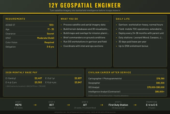
This is one of the Army’s most technically specialized enlisted jobs. It sits inside the Corps of Engineers (CMF 12), requires a competitive ASVAB score, and leads to civilian careers in GIS, remote sensing, and defense contracting that pay well above median wages. The Army currently offers an enlistment bonus of up to $15,000 for qualified recruits.
Qualifying requires specific ASVAB line scores — our ASVAB study guide covers what to target and how to prepare.
Job Role and Responsibilities
Geospatial Engineers collect, process, and distribute geographic and imagery intelligence to support Army operations. They extract terrain data from satellite and aerial sources, build digital maps and 3D visualizations, and brief commanders on ground conditions before and during missions. This work directly influences how units move, where they position weapons, and how they respond to threats.
Daily Tasks
The day-to-day work is technical and screen-heavy in garrison. A 12Y analyst spends hours processing raw satellite imagery using specialized software, building terrain databases, and generating products for planning cells. In the field, that shifts to running geospatial workstations from vehicles or command posts, often under time pressure.
Common daily tasks include:
- Collecting geographic data from satellite and aerial imagery sources
- Operating Geographic Information System (GIS) software to build and update terrain databases
- Creating maps, overlays, charts, and 3D battlefield visualizations
- Briefing commanders on terrain analysis findings
- Operating and maintaining geospatial workstations and imagery exploitation systems
- Coordinating with intelligence and operations sections to deliver time-sensitive products
Specialization
Within CMF 12, the 12Y MOS has no formal ASI (Additional Skill Identifier) sub-tracks at entry, but experienced soldiers can pursue advanced training in imagery intelligence and terrain analysis. At senior grades, 12Ys can be detailed to GEOINT (Geospatial Intelligence) billets that work closely with National Geospatial-Intelligence Agency (NGA) assets.
Mission Contribution
Geospatial Engineers are what commanders call “ground truth” providers. A unit walking into a new area of operations relies on 12Y products to understand elevation, trafficability, cover and concealment, and likely enemy avenues of approach. Bad terrain analysis leads to bad decisions. Good 12Y work reduces surprise.
Technology and Equipment
The job is technology-intensive. Soldiers work with:
- ArcGIS, ENVI, and military-specific GIS platforms
- Imagery exploitation workstations (IEWs)
- Remote sensing datasets (multispectral, hyperspectral, LiDAR)
- Tactical computer systems and classified networks
- Unmanned aircraft system (UAS) imagery feeds
Salary and Benefits
Base Pay
All Army pay is set by the 2026 DFAS pay tables. Soldiers enter at E-1 or E-3 depending on prior education credit.
| Rank | Time in Service | Monthly Base Pay |
|---|---|---|
| E-1 (PV1) | Entry | $2,407 |
| E-2 (PV2) | 6 months | $2,698 |
| E-3 (PFC) | 1 year | $2,837 |
| E-4 (SPC) | 2 years | $3,303 |
| E-5 (SGT) | 4 years | $3,947 |
| E-6 (SSG) | 8 years | $4,613 |
Allowances and Additional Benefits
Base pay is only part of the total compensation picture. Soldiers who live off-post receive Basic Allowance for Housing (BAH), which varies by duty location and dependent status. An E-4 at Fort Leonard Wood receives roughly $1,200 to $1,500 per month in BAH. All enlisted soldiers receive a flat Basic Allowance for Subsistence (BAS) of $476.95 per month in 2026.
Other benefits include:
- TRICARE: Free medical, dental, and vision coverage for the soldier; low-cost coverage for dependents
- Enlistment bonus: Up to $15,000 for 12Y (verify current status with recruiter)
- Tuition Assistance (TA): Up to $4,500 per year for college courses while serving
- Post-9/11 GI Bill: Up to 36 months of education benefits after service, covering full in-state tuition at public universities plus a monthly housing allowance
Retirement
Soldiers who joined after January 2018 fall under the Blended Retirement System (BRS). It combines a 20-year pension worth 40% of your highest 36-month average basic pay with a Thrift Savings Plan (TSP) that includes government matching contributions of up to 5% of basic pay.
Work-Life Balance
The Army’s leave policy provides 30 days of paid leave per year, accruing at 2.5 days per month. Garrison assignments at Fort Leonard Wood or other CONUS installations follow a relatively predictable Monday-to-Friday schedule with periodic field exercises. Pre-deployment training cycles are more demanding.
Qualifications and Eligibility
Requirements Table
| Requirement | Details |
|---|---|
| ASVAB Line Score | ST: 100 |
| Age | 17-35 (waiver possible to 39) |
| Citizenship | U.S. citizen or permanent resident alien |
| Education | High school diploma or GED |
| Security Clearance | Secret (must be eligible) |
| Physical Demand | Moderate (OPAT Gold category) |
| OPAT Minimum | SJ: 120 cm / PT: 350 cm / SD: 120 lbs / IR: 36 shuttles |
| Color Vision | Required for imagery analysis |
| AFQT Minimum | 31 (HS diploma) or 50 (GED) |
The ST (Skilled Technical) composite is calculated from GS + VE + MK + MC subtest scores. A score of 100 is above average and typically requires solid performance across math, reading, and mechanical comprehension.
Application Process
- Meet with an Army recruiter and take the ASVAB at a Military Entrance Processing Station (MEPS)
- Pass the physical examination and OPAT testing at MEPS
- Confirm eligibility for a Secret security clearance (background investigation covers finances, criminal history, and foreign contacts)
- Request MOS 12Y when completing your enlistment contract
Selection and Competitiveness
The ST 100 minimum is moderately competitive. Recruits who have taken algebra, trigonometry, or GIS coursework in high school have a noticeable advantage. The Secret clearance requirement disqualifies applicants with certain criminal records or significant foreign financial ties.
Service Obligation
Standard enlistment contracts are 3, 4, or 6 years on active duty. Soldiers who take an enlistment bonus typically incur a 4- or 6-year obligation. The AIT pipeline for 12Y runs just over 30 weeks total (BCT plus AIT), so plan for roughly 7 months of training before reaching your first duty station.
See our ASVAB study guide for strategies to hit these line scores, or take the PiCAT from home if you are a first-time tester.
Work Environment
Setting and Schedule
Geospatial Engineers spend most of their garrison time indoors at workstations on classified or unclassified networks. Field exercises pull them into tactical operations centers (TOCs) where they run geospatial systems from mobile platforms. Deployments add austere conditions: generators, limited connectivity, and time-critical production requirements.
The garrison workday typically follows normal duty hours, though mission requirements can extend that during training rotations or real-world operations. Shift work is common at higher-level commands where geospatial support runs around the clock.
Chain of Command
12Y soldiers typically work within engineer battalions or brigade combat team (BCT) staff sections, reporting through an NCO team leader to a geospatial section chief (usually a senior NCO or warrant officer). At Corps or Army-level commands, they may work alongside NGA civilians and contractors in joint geospatial cells.
Team Dynamics
The work requires both independent analytical judgment and tight coordination with operations and intelligence sections. A 12Y often builds a product alone, then validates it through discussion with the S2 (intelligence officer) or S3 (operations officer). At lower echelons, the section may have only 2-4 soldiers, so each person carries significant responsibility.
Job Satisfaction
Soldiers in this MOS frequently cite the technical depth of the work and the direct connection to mission planning as the top reasons they stay. The career path into GIS and geospatial intelligence is strong, and defense contractors actively recruit experienced 12Ys. Re-enlistment incentives are available for this MOS.
Training and Skill Development
Initial Training
| Phase | Location | Length | Focus |
|---|---|---|---|
| Basic Combat Training (BCT) | Various | 10 weeks | Soldier fundamentals, weapons, fitness |
| Advanced Individual Training (AIT) | Fort Leonard Wood, MO | 20 weeks | GIS software, terrain analysis, imagery exploitation |
| First Duty Station | Varies | Ongoing | On-the-job geospatial production |
AIT at Fort Leonard Wood is run by the Army Geospatial Center’s training pipeline. The 20-week course covers GIS fundamentals, imagery interpretation, terrain analysis theory, and hands-on production with the software suites the Army actually uses. Soldiers graduate with skills directly transferable to civilian GIS positions.
Advanced Training
Experienced 12Ys can attend:
- Imagery Intelligence (IMINT) courses at the National Geospatial-Intelligence College
- Advanced GIS certifications through Army COOL (Credentialing Opportunities On-Line)
- Remote Pilot Certificate (FAA Part 107) training for UAS exploitation billets
- Non-Commissioned Officer Education System (NCOES) professional development courses as they promote
The Army COOL program funds civilian certifications like the Geographic Information Systems Professional (GISP) credential, which is valued by defense contractors and government agencies.
Everything starts with qualifying ASVAB scores — our study guide covers what to study first.
Career Progression and Advancement
Rank Progression
| Grade | Title | Typical Time in Grade | Key Milestone |
|---|---|---|---|
| E-1 to E-3 | Private / PFC | 0-18 months | Complete AIT, arrive at first unit |
| E-4 | Specialist (SPC) | 18-36 months | Lead independent geospatial production |
| E-5 | Sergeant (SGT) | 3-6 years | Supervise junior analysts, lead AIT |
| E-6 | Staff Sergeant (SSG) | 6-10 years | Run section-level operations |
| E-7 | Sergeant First Class (SFC) | 10-15 years | Platoon Sergeant |
| E-8 | Master Sergeant (MSG) | 15-20+ years | Senior technical advisor |
Specialization and Transfers
Senior 12Ys can pursue reclassification into warrant officer tracks (typically 12T Technical Engineering Technician) or lateral moves into intelligence-adjacent roles. The geospatial skill set also opens doors to joint billets at NGA, DIA, and U.S. Army Corps of Engineers (USACE) geospatial operations centers.
Performance Evaluation
NCOs are evaluated through the Non-Commissioned Officer Evaluation Report (NCOER), which grades performance in five areas: competence, leadership, training, responsibility, and physical fitness. Strong NCOER ratings drive promotion board selection. For technical MOSs like 12Y, demonstrated proficiency with software platforms and production quality under pressure are visible differentiators.
Physical Demands and Medical Evaluations
Fitness Standards
12Y is rated Moderate physical demand, which means the AFT general standard applies. Every soldier must pass the Army Fitness Test (AFT), which replaced the ACFT on June 1, 2025.
| AFT Event | Description | Min Score |
|---|---|---|
| MDL | 3-Rep Max Deadlift | 60 pts |
| HRP | Hand Release Push-Up | 60 pts |
| SDC | Sprint-Drag-Carry | 60 pts |
| PLK | Plank | 60 pts |
| 2MR | Two-Mile Run | 60 pts |
| Total | 300 pts minimum |
Scores are sex- and age-normed. Maximum possible score is 500. Soldiers scoring below 60 on any single event fail the AFT regardless of total score.
OPAT
The Occupational Physical Assessment Test (OPAT) screens recruits before enlistment. The 12Y Moderate (Gold) category requires:
- Standing Long Jump: 120 cm minimum
- Seated Power Throw: 350 cm minimum
- Strength Deadlift: 120 lbs minimum
- Interval Aerobic Run: 36 shuttles minimum
Medical Evaluations
Active-duty soldiers complete a periodic physical every year. The security clearance renewal process includes a medical review. Color vision is important for imagery analysis, though specific waivers may be available depending on severity.
Deployment and Duty Stations
Deployment Pattern
12Y Geospatial Engineers deploy with their parent units. An engineer battalion or BCT headquarters staff will typically deploy every 24-36 months under current operational tempo. Deployment lengths are typically 9-12 months. During deployments, 12Ys often operate from joint operations centers and may be the primary or only geospatial support for the headquarters.
Duty Stations
Common 12Y assignments include:
- Fort Leonard Wood, MO (training base, follow-on assignments available)
- Fort Cavazos, TX (III Corps)
- Fort Campbell, KY (101st Airborne)
- Fort Wainwright, AK (Arctic brigade)
- Joint Base Lewis-McChord, WA (I Corps)
- Joint Base Langley-Eustis, VA (Army Geospatial Center)
- Various OCONUS locations (Korea, Germany, Japan)
Duty station preferences can be listed on your enlistment contract, though the Army makes final assignments based on needs of the force.
Risk, Safety, and Legal Considerations
Job Hazards
The core work of a 12Y is low physical risk compared to combat arms. Soldiers work primarily at workstations. The main hazards are those common to any deployed soldier: indirect fire, vehicle accidents, and the physical demands of extended field operations.
Safety Protocols
When deploying, 12Y soldiers receive theater-specific safety briefings and operate within force protection measures. Classified system operations require adherence to strict cybersecurity protocols and handling procedures.
Security Requirements
A Secret clearance is required at entry. With experience, some 12Ys receive access to higher classification levels depending on their assignment. The clearance investigation covers the past 7-10 years of financial history, criminal records, foreign travel, and foreign contacts. Loss of clearance results in reclassification.
The service contract is a binding legal obligation. Early separation requires an Army-initiated action (medical, hardship, etc.) or specific administrative processes. Enlistment bonus recoupment provisions apply if a soldier separates before completing the contract term.
Impact on Family and Personal Life
Family Considerations
Garrison life at most 12Y duty stations is manageable for families. Normal duty hours mean evenings and weekends are generally free. Pre-deployment training cycles of 3-6 months increase the tempo significantly. Deployment separations of 9-12 months are the biggest family stressor.
The Army provides support through Military OneSource, Army Community Service (ACS), and Family Readiness Groups (FRGs) that organize support networks during deployments.
Relocation
Soldiers can expect to move to a new duty station every 2-4 years. Permanent Change of Station (PCS) moves are funded by the Army and include a dislocation allowance. Frequent moves can disrupt spousal employment and children’s school continuity. Some families find the combination of housing allowance and reduced cost of living near military bases actually improves their financial situation compared to comparable civilian roles.
Reserve and National Guard
Component Availability
The 12Y MOS is available in both the Army Reserve and Army National Guard. Geospatial engineer slots exist in engineer battalions, topographic units, and some intelligence-support elements across both components. Positions are less numerous than general engineer MOSs, so you may need to look beyond your nearest unit to find an open 12Y slot.
Drill Schedule and Training Commitment
Standard commitment is one weekend per month plus two weeks of Annual Training. 12Y soldiers need to maintain proficiency on GIS software, digital terrain analysis tools, and mapping systems. Some of this can be done during regular drill weekends, but Annual Training typically involves producing terrain products or survey data for training exercises. You may need additional computer lab time to stay current on software updates.
Part-Time Pay
An E-4 with about three years of service earns roughly $422 per drill weekend in 2026, totaling about $5,064 over 12 weekends. Annual Training adds around $1,583, for an annual total near $6,647. Active-duty E-4 monthly base pay sits at $3,166 for comparison.
Benefits Differences
Reserve and Guard 12Y soldiers get Tricare Reserve Select rather than free active-duty TRICARE. TRS premiums run $57.88 per month for member-only or $286.66 for member plus family in 2026.
Education benefits include:
- Federal Tuition Assistance: $4,500 per year for drilling members
- MGIB-SR: roughly $416 per month while enrolled
- Post-9/11 GI Bill: requires 90 or more days of federal activation; benefit percentage scales with active time
- State tuition waivers (Guard only): vary by state, with some covering full tuition at state universities
Retirement follows the points-based system. The pension draws at age 60, though qualifying mobilizations can lower that by 90 days per qualifying period, down to a minimum of age 50. TSP matching up to 5% applies under the Blended Retirement System.
Deployment and Mobilization
Geospatial engineers mobilize at a moderate rate. Reserve and Guard 12Y soldiers may deploy to produce terrain analysis, map products, and geospatial intelligence for operations planning. Mobilizations typically last 9 to 12 months. The demand for geospatial support stays steady, so expect at least one mobilization during a six-year enlistment.
Civilian Career Integration
The 12Y MOS maps directly to civilian GIS and surveying careers. Many Reserve and Guard geospatial engineers work as GIS analysts, cartographers, surveyors, or remote sensing specialists during the week. The technical skills you practice during drill translate to software platforms like ArcGIS and QGIS that civilian employers use daily. USERRA protects your civilian position when you are called to military duty, and your employer must hold your job and restore benefits upon return.
| Feature | Active Duty | Army Reserve | Army National Guard |
|---|---|---|---|
| Commitment | Full-time | One weekend/month + 2 weeks/year | One weekend/month + 2 weeks/year |
| Monthly Pay (E-4, ~3 yrs) | $3,166/month | ~$422/drill weekend | ~$422/drill weekend |
| Healthcare | TRICARE, $0 premiums | TRS, $57.88/month (member) | TRS, $57.88/month (member) |
| Education | TA + Post-9/11 GI Bill | Federal TA, MGIB-SR; Post-9/11 after activation | Federal TA, MGIB-SR, state tuition waivers |
| Deployment | Regular rotations | Mobilization every 3-5 years | Mobilization every 3-5 years |
| Retirement | BRS pension at 20 years | Points-based, age 60 | Points-based, age 60 |
Post-Service Opportunities
Geospatial Engineer training maps directly to a strong civilian career path. The GIS and remote sensing industry has grown rapidly, driven by demand from defense contractors, utility companies, environmental firms, and technology companies.
| Civilian Job Title | Median Annual Salary | Job Outlook |
|---|---|---|
| Cartographer / Photogrammetrist | $78,380 | +6% (2024-2034) |
| Geographer | $80,300 | +4% (est.) |
| Surveyor | $68,340 | +5% (est.) |
| GIS Analyst / Specialist | $75,000-$95,000 | Strong demand |
| Intelligence Analyst (Contractor) | $85,000-$115,000 | High demand |
Salary data for cartographers and photogrammetrists is from BLS Occupational Outlook Handbook (May 2024 data).
Veterans transitioning from 12Y can apply for the GISP certification through the Army COOL program, which covers exam fees. A TS/SCI clearance obtained during service is a major asset for defense contractor positions that routinely pay $90,000-$130,000+.
The Post-9/11 GI Bill covers 36 months of education, enough for a bachelor’s degree in geospatial science, geography, or civil engineering. Many 4-year GIS programs grant credit for AIT coursework.
Is This a Good Job for You? The Right (and Wrong) Fit
Ideal Candidate
This MOS suits someone who:
- Likes working with maps, data visualization, or geography
- Is comfortable spending long hours at a computer doing analytical work
- Has solid math skills and attention to detail
- Wants a technical career with clear civilian pathways
- Can work independently on complex products but also communicate findings clearly
Potential Challenges
The job is desk-heavy. If you joined the Army for constant physical activity and outdoor work, long AIT days in front of GIS software screens may feel frustrating. Deployments add combat zone risk even though the primary work is analytical. The security clearance process can delay entry if your background has complications.
Re-enlistment rates in technical engineer MOSs are moderate. Some soldiers find the technical depth rewarding and stay long careers. Others transition quickly into defense contractor GIS roles where salaries exceed military pay by year 4 or 5.
Career and Lifestyle Alignment
If you want a technical career with hands-on mission impact and a clear bridge to a well-paying civilian job, 12Y is a strong choice. The combination of GIS skills, security clearance, and military experience is genuinely valued in defense contracting and government agencies. If you want physical action and field operations as the core of your service, look at the combat engineer track (12B) instead.
More Information
Talk to an Army recruiter to confirm current bonus amounts, training schedules, and available duty stations for MOS 12Y. You can also call GoArmy at 1-888-550-ARMY (2769) or visit your local recruiting office.
- Prepare for the ASVAB with our study guide to make sure your line scores qualify
This site is not affiliated with the U.S. Army or any government agency. Verify all information with official Army sources before making enlistment or career decisions.
Explore more Army engineer careers such as 12B Combat Engineer and 12C Bridge Crewmember.